GeoDin Onsite Trial 6 months
GeoDin Onsite Trial 6 months
Digital field data collection for geotechnical professionals
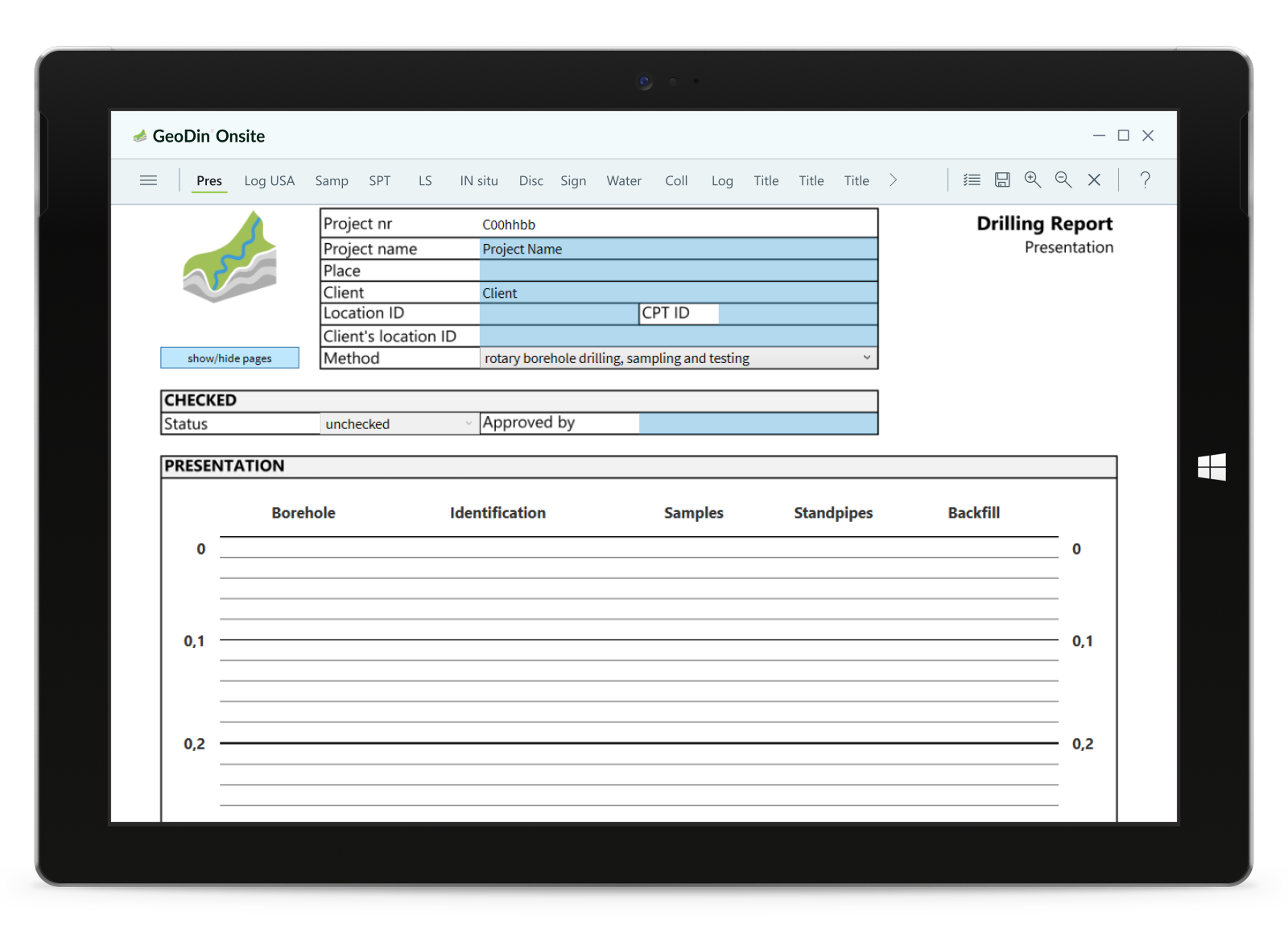
GeoDin Onsite transforms traditional paper-based field data collection into an efficient digital workflow. Designed specifically for geotechnical drilling operations, this Windows-based application brings the simplicity of paper forms to digital tablets with powerful validation and integration capabilities.
This free trial is valid for 6 months. No creditcard needed to get started. To get extended access, please reach out to sales@geodin.com.
Key features
- Intuitive layout-driven design: familiar paper-like interface with low adoption threshold for field staff
- smart validation: automatic checks ensure data completeness and accuracy before submission
- offline capability: work anywhere without internet connection for up to 30 days
- integrated sample management: generate QR-coded labels on-site for seamless sample tracking
- multilingual support: available in English, Spanish, French, Dutch, German, and Portuguese
- seamless GeoDin integration: export data directly to GeoDin desktop with one-click submission
- comprehensive field forms: capture detailed drilling information, soil layers, samples, and more
Perfect for
- geotechnical engineering firms conducting field drilling operations
- organizations looking to eliminate paper forms and manual data re-entry
- teams requiring efficient sample management and tracking systems
- projects in remote locations with limited connectivity
Transform your field data collection workflows, reduce errors, and save valuable time with GeoDin Onsite – the digital clipboard designed by geotechnical professionals for geotechnical professionals.
Product Note
Subscribe and save
Frequently Asked Questions
If you don’t see your question here, we’re always available to help.
Get in touch to discuss your needs, explore opportunities, or clarify how we work.
Contact usVisualize your ground data in detail
– a carefully crafted collection of specialized tools designed to support every aspect of your geotechnical workflows.

"Being geotechnical engineers by heart, we believe delivering a solid software foundation from the beginning is key to our customers' success. No waiting for essential features - they're already here."


"While OpenGround offers some useful features, we're concerned about the long-term ownership of our valuable geotechnical data. Relying on a third-party platform raises questions about data security and accessibility. We need a solution that gives us full control over our data, without any vendor lock-in."

"My personal favorite feature is the customizable grid view for measurement data. GeoDin® is an ideal combination of client-server software with all advantages of a typical multi-user database solution and a high-specialized software for our subject matter experts."
Build on solid ground today with GeoDin.
Try GeoDin for 30 days and see if it holds up to OpenGround. Contact us on how to migrate from OpenGround to GeoDin - we'll be expecting your call.