GeoDin
Embark on Your Full GeoDin Experience
Dive into the expansive GeoDin universe with a 12-month full access. Invest in GeoDin for a year to get the ultimate geotechnical data management experience, and retain your data's accessibility for a lifetime. Your data remains your own, always reachable, regardless of subscription status.
- Manage and integrate geodata.
- Compliant with top geological standards.
- Full transparency on data engine, custom formulas possible.
- Data export to AGS Format.
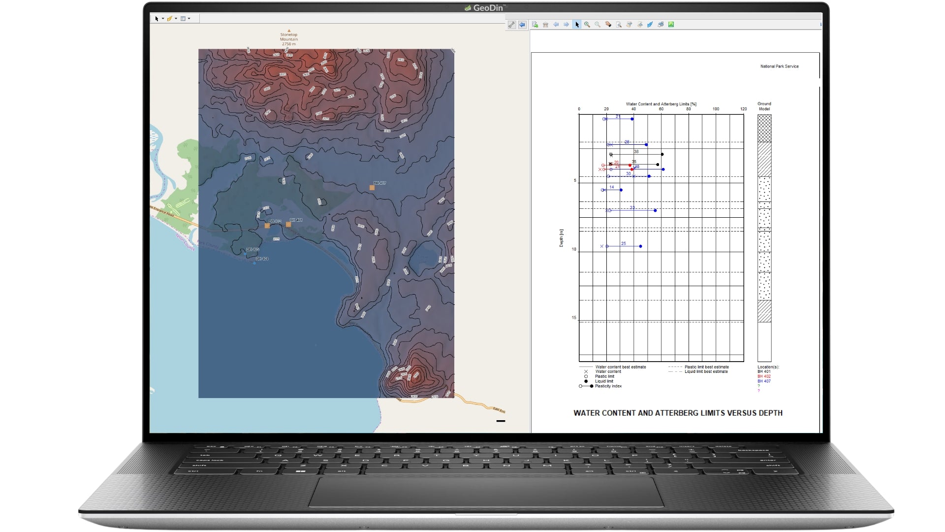
- Template reports with impressive visualization.
System requirements
- Microsoft Windows® 10, 4 GB RAM
- Display resolution of 1920x1080
Choose Your Licensing Type:
Individual License
- Each unit provides a unique license key for use on one machine or instance.
- Ideal for those who need a personalized setup with the freedom to manage their own geotechnical projects.
Professional License (also known as 'network license')
- A network license allows your entire team to access GeoDin from anywhere in your office or remotely, using just one shared license, ensuring flexibility and cost savings for your business.
- The total number of licenses determines the maximum number of possible simultaneous users.
- Designed for organizations needing a shared solution.
Educational License
- Students and teacher can apply for an Educational license, since we want to stimulate the education of geotechnical engineering. We will verify your details after purchase.
Tiered discounts
- Buying 11 - 50 seats will give you 10% off.
- Buying 51 - 100 seats will give you 15% off.
- Buying 101 - 300 seats will give you 20% off.
- Buying more than 300 seats? Please Contact Sales for a personalized offer.
Discounts will be automatically added to your cart when checking out.
Product Note
Subscribe and save
Frequently Asked Questions
If you don’t see your question here, we’re always available to help.
Get in touch to discuss your needs, explore opportunities, or clarify how we work.
Contact usVisualize your ground data in detail
– a carefully crafted collection of specialized tools designed to support every aspect of your geotechnical workflows.

"Being geotechnical engineers by heart, we believe delivering a solid software foundation from the beginning is key to our customers' success. No waiting for essential features - they're already here."


"While OpenGround offers some useful features, we're concerned about the long-term ownership of our valuable geotechnical data. Relying on a third-party platform raises questions about data security and accessibility. We need a solution that gives us full control over our data, without any vendor lock-in."

"My personal favorite feature is the customizable grid view for measurement data. GeoDin® is an ideal combination of client-server software with all advantages of a typical multi-user database solution and a high-specialized software for our subject matter experts."
Build on solid ground today with GeoDin.
Try GeoDin for 30 days and see if it holds up to OpenGround. Contact us on how to migrate from OpenGround to GeoDin - we'll be expecting your call.